|
Survey of the Southern Part of the Mahale Mountains
Michio Nakamura1, Hitonaru Nishie1, and Crispin Mwinuka2, 3
2. Mahale Mountains National Park 3. Mahale Mountains Wildlife Research Centre INTRODUCTION The Mahale Mountains National Park contains the majority of chimpanzees (Pan troglodytes schweinfurthii) in Tanzania1. However, after initial research stages, studies have mainly focused on habituated chimpanzee groups (see 2 for details) that inhabit the northern part of the park. Consequently, recent information on unhabituated chimpanzee groups is mostly from adjacent groups of the main study group, M group (e.g, 3, 4, 5, and 6). Although there have been recent surveys further to the north7 and further to the east8, no systematic survey further south has been recently conducted. The objective of this survey is to obtain general information of the southern part of the park: the occurrences of chimpanzees and other large mammals, the vegetation types, and the degree of human disturbance that can be useful for area conservation.
We counted chimpanzee beds found from the survey route and estimated the distance from the route by eye. We roughly estimated the age of the beds and identified the species of their host trees. Chimpanzee vocalization, food remains, or feces were also recorded whenever encountered. We also recorded direct and indirect evidence of other large mammals and made rough sketches of vegetation types and human disturbance (e.g., remains of cultivation, fire, etc.).
The evidence for large mammals is summarized in Table 1. Direct observations of mammals were rare, perhaps because of the destroyed vegetation. Animals may have detected us before we noticed them. Although much of the chimpanzee evidence we found (plotted in Figure 1) was old beds, we heard calls twice and saw some fresh feces. Table 2 shows the species of the host trees of the chimpanzee beds.
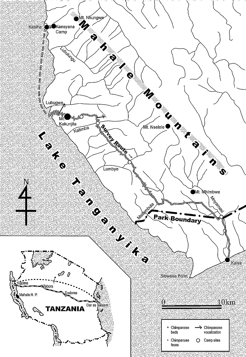
Figure 1. Southern part of the Mahale Mountains National Park and the survey route. 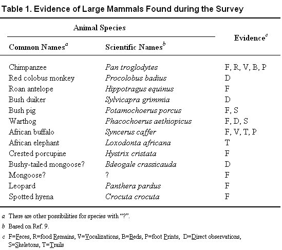
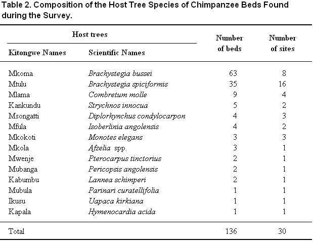
DISCUSSION Judging from the distribution of chimpanzee evidence, the ranging patterns of known groups, the vegetation, and the geographical characteristics, we estimated that our survey area covered the ranges of five unit groups, each mainly utilizing the riverine forests of Lubugwe, Msuma, Katimba, Lumbye, and Msilambula, respectively. We need additional surveys to confirm our assumptions. To estimate the number of chimpanzees inhabiting this area, we need information of the speed of bed decay. Since most bed trees we found were Brachystegia, which are common in Miombo woodlands, bed decay data for these tree species have to be collected in dry Miombo woodlands. We tried to walk straight to gather less biased data of chimpanzee beds. However, this was difficult due to two reasons. One is the landscape. Although we managed to cross the Katimba Valley without any special equipment, we had to cautiously select the safest route, and so we could not merely walk straight. Secondly, we quit walking straight because of a lack of water. Unlike a census in moist rain forests, it is hard to find water in a savanna woodland during the dry season. This is a serious obstacle when considering a wider census in Mahale. Just as the eastern area of the Mahale National Park8, the area south of Lumbye was badly burned. Even here we found old chimpanzee beds (especially around Msilambula), but we did not find recent evidence in such dry and burned areas. This suggests that chimpanzees utilize this area only in rainy season and migrate to other areas (perhaps near the lakeshore1) in dry season. If so, it means that the chimpanzees are forced to range wider because of human disturbance even within the protected area. An effective fire management plan is promptly required to cover the entire area of the park.
Back to Contents |